.png.transform/rendition-xs/image_image%20(1).png "Feder")
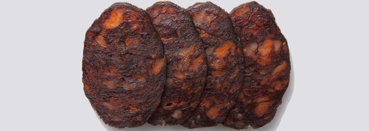
Ibérico black sausage
Sausage product made with fat from Ibérico pork and coagulated blood. This product is normally seasoned with salt, garlic, and paprika as well as other spices and condiments. It has a curing process of approximately two months. It can be eaten raw, fried, roast, grilled or in casseroles.
Other notes
Sausage product made with seasoned Ibérico pork, with pig's blood, pimentón, garlic and natural spices.
Production / Processing method
The main ingredients necessary for its production, depending on the area and the recipe, are the following: lean pork meat, rice, pork lard, pig's blood and onion, common salt, pimentón, pepper, oregano and other permitted spices: thyme, clove, coriander and/or cinnamon.
The meat and pork fats are minced, seasoned and left to stand. They are then stuffed into a natural pork casing and allowed to cool, and then subjected to a curing process of approximately 2 months, depending on the weight of the sausage.
Geography / Relief and climate
The Autonomous Region of Andalusia has an area of 87,598 km2, and is located in the southern part of the Iberian Peninsula, bordering on Portugal to the west, the Atlantic Ocean and the Mediterranean Sea to the south and southeast, the Autonomous Region of Murcia to the east, and the Autonomous Regions of Extremadura (province of Badajoz), Castile-La Mancha (provinces of Ciudad Real and Albacete) and Murcia to the north. It comprises the provinces of Almería (8,775 km2), Cadiz (7,436 km2), Cordoba (13,771 km2), Granada (12,647 km2), Huelva (10,128 km2), Jaén (13.496 km2), Malaga (7.308 km2) and Seville (14,036 km2).
In Andalusia there are three different areas: the Guadalquivir valley, the Sierra Morena, and the Cordillera Bética mountain ranges. The highest peaks in the region are: Mulhacén (3,482 km2, in the Sierra Nevada mountains in Granada), Chullo (2,609 km2, in the Sierra Nevada in Almería) and Mágina (2,167 km2, in the Sierra Mágina in Jaén).
The Autonomous Region of Castile-León has an area of 94,225.96 km2. It is formed by the provinces of Avila (8,050 km2), Burgos (14.,291 km2), León (15,581 km2), Palencia (8.,053 km2), Salamanca (12,350 km2), Segovia (6.923 km2), Soria (10.307 km2), Valladolid (8,110 km2) and Zamora (10,561 km2). It has an average height above sea level of 830 meters, and the highest peaks are over 2,500 meters, with the highest of all –Torrecerredo, with a height of 2,648 meters– in the Picos de Europa mountains. Annual rainfall, depending on the province, ranges between 697.8 mm and 410.7 mm. It has a continental oceanic climate, characterized by hot summers and cold winters, with short periods of fall and spring. Its maximum temperatures range from 39ºC in summer and -12ºC in winter, with an average temperature of 12ºC.
The Autonomous Region of Extremadura has an area of 41,581.98 km2 and comprises the provinces of Badajoz (21,714 km2) and Caceres (19,868 km2). It borders on Portugal to the west, the Autonomous Region of Castile–La Mancha (Toledo and Ciudad Real) to the east, the Autonomous Region of Castile-León (Avila and Salamanca) to the north, and Andalusia (Huelva, Seville and Cordoba) to the south. The rainfall ranges between 400 and 800 mm. It has a continental Mediterranean climate with an Atlantic influence. In this area the winters are mild and the temperatures may occasionally fall to 0ºC, while in contrast the summers are very warm with maximum temperatures which reach 40ºC. The annual average precipitation is 475 mm. The climate has its maximum instability in the fall, a period in which storms occur with greater frequency. There is little wind, and frequent mists.
The main production zones are linked to the system of wooded pastures known as the dehesa (an ecosystem deriving from the Mediterranean forest with a predominance of holm oaks and cork oaks, and with an abundance of Iberico pig farms).